LiDAR Technology

Driving Success with Autonomous Vehicles

Automotive Lidar - Innoviz

Light Detection & Ranging

Understanding LiDAR

LiDAR is a powerful and versatile technology that provides many industries with the accurate, real-time 3D sensing they need. Relying heavily on sensors that supply their own illumination source, LiDAR sensors hit objects and use the energy source that bounces back to detect, measure, and create 3D maps of its environment. Distance to the objects in the environment are determined by recording the time between transmitted and backscattered pulses and by using the speed of light to calculate the distance traveled.

Lidar Tech for Autonomous Vehicles
Innoviz LiDAR Tech & Perception Software

Innoviz LiDAR Technology

Innoviz has developed two high-performance automotive-grade solid-state LiDAR sensors, plus industry-leading perception software.

While LiDAR boasts use in many industries and applications, InnovizOne was specifically designed for automakers and robotaxis, shuttle and delivery companies in need of an automotive-grade, mass-producible solution for autonomy. With a detection range of up to 250m, 0.1°x0.1° angular resolution (HxV), and configurable frame rate of 5-20 FPS, InnovizOne was designed and developed to achieve the industry’s highest standards.

A fully-featured, high-performance, automotive-grade LiDAR sensor, the InnovizTwo has been designed and developed for all levels of autonomous driving at a dramatically reduced cost. The unit serves several industry applications (consumer vehicles, industrial drones, heavy machinery, and more) and boasts performance increases in range (up to 300m), angular resolution (0.07°x0.05°), field of view (125°x40°), configurable frame rate of 10-20 FPS, and more.

InnovizTwo Key Performance Metrics

0.07°x0.05°

Angular Resolution (HxV)

10-20 FPS

Configurable Frame Rate

0.1m to 300m

Detection Range

125°x40°

Field of View (HxV)

70x124x120

Dimensions (HxWxD)

ASIL B(D)

ISO 26262 Compliant

Innovation in LiDAR Technology

  • 1
  • 2
  • 3

Safety

Safety is crucial for the adoption of autonomous vehicles by the general public. Technical accuracy under normal conditions is expected, however, LiDAR makes it possible for autonomous vehicles to maneuver safely and effectively across a range of environments and conditions.

LiDAR is advancing to withstand adverse weather conditions like rain, snow, fog, and dust with greater accuracy. The InnovizOne can deliver a 3D point cloud at distances up to 250 meters, while maintaining resistance to a variety of weather conditions, regardless of sunlight.

Tough terrain presents challenges of its own. Solid-state sensors, as opposed to mechanical sensors, also have the ability to withstand bumpy roads, rocky terrain and heavy vibrations. Despite the range of conditions automobiles face on a day-to-day basis, LiDAR continues to evolve to provide the safety and endurance required to continue performing as expected.

Scalability and Mass Production

Innoviz has partnered with Tier 1 suppliers to improve the production of its solid-state LiDAR sensors made of mostly semiconductor components (primarily chips), which lowers cost and increases performance and reliability.

The approach at Innoviz is primed to enable the large-scale production of LiDAR for autonomous vehicles, including optimizing manufacturing methods through the use of data logs, implementing an automated test process as opposed to manual, and incorporating active alignment for assembly.

As with nearly any technology that has been around for a significant amount of time, as advancements and efficiencies increase, barriers such as cost will decrease for industries and consumers alike.

Object Detection

Being able to detect objects, near and far, with precision is crucial. Technology like Innoviz’s perception software is the perfect complement to its LiDAR offerings and boasts two independent object identifying detectors. This allows the LiDAR sensor to not only “see” things but classify them as pedestrians, bicycles, cars, trucks, and so on.

With perception (being able to identify and classify objects) and prediction (being able to determine the position of an object in the future) being among the greatest technological issues for autonomous vehicles, Innoviz’s perception software allows the LiDAR to understand what is being “seen,” providing leading classification, pixel collision classification, and continuous calibration capabilities in addition to object identification and tracking.

View Next

The History of LiDAR Technology

LiDAR technology made strides in its relatively short history. In the 1930s, the first attempt to study atmospheric structure was performed using searchlights. The height of clouds was determined using light pulses in 1938. It wasn’t until after the invention of the laser beam in 1960 that LiDAR as we recognize it today was first used as the platform for laser beams on airplanes. It would be nearly 30 years later, however, before accurate LiDAR data would be made commercially available using Global Position Systems (GPS) and internal measurement units (IMUs).

LiDAR Technology Today

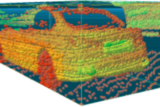
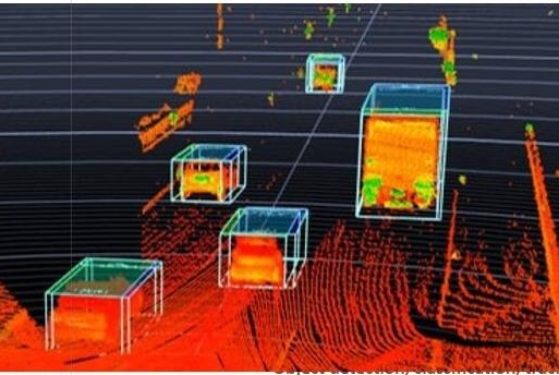
Nowadays, LiDAR advancements are being achieved exponentially. Uses cover a range of applications including the more established archaeology, shoreline mapping, and emergency response to the more modern robots, autonomous vehicles, and augmented reality (AR).

Performance improvements in the automotive space is leading to safer, more affordable autonomous vehicles for industries, automakers and, ultimately, consumers. Some notable advancements in LiDAR in recent years include: